  | 
          
            This is a file from the  Wikimedia Commons. Information from its  description page there is shown below.  Commons is a freely licensed media file repository.  You can help. 
           | 


        Summary 


           | DescriptionEurope countries map en 2.png | 
           
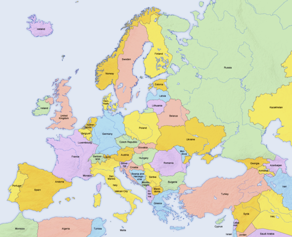
             English: Map of countries in  Europe and the surrounding region 
            | 
          
          
           | Date | 
           02.04.2006 | 
          
          
           | Source | 
           derivative work of  Europe countries map en.png by  San Jose, based on the  Generic Mapping Tools and  ETOPO2 | 
          
          
           | Author | 
            San Jose (map),  Hayden120 (retouch) | 
          
          
           Permission ( Reusing this file) | 


                 | 
              The map has been created with the  Generic Mapping Tools:  http://gmt.soest.hawaii.edu/ using one or more of these  public domain datasets for the relief: 
                - ETOPO2 ( topography/ bathymetry):  http://www.ngdc.noaa.gov/mgg/global/global.html
 
                - GLOBE ( topography):  http://www.ngdc.noaa.gov/mgg/topo/gltiles.html
 
                - SRTM ( topography):  http://www2.jpl.nasa.gov/srtm/
 
                
               | 


                | 
              Permission is granted to copy, distribute and/or modify this document under the terms of the  GNU Free Documentation License, Version 1.2 or any later version published by the  Free Software Foundation; with no Invariant Sections, no Front-Cover Texts, and no Back-Cover Texts. A copy of the license is included in the section entitled  GNU Free Documentation License.  http://www.gnu.org/copyleft/fdl.htmlGFDLGNU Free Documentation Licensetruetrue 
               | 


            | 


            | 
          This is a  retouched picture, which means that it has been digitally altered from its original version. Modifications: Saturation, brightness, contrast. The original can be viewed here:  Europe countries map en.png. Modifications made by  Hayden120. 
              
           | 
         
        
        See also 
        
         
          |  Maps of the history of Europe | 
         
         
           BC aC | 
          
             Middle Neolithic ·  Late Neolithic ·  220 
           | 


           | 
         
         
           AD dC | 
          
             60 ·  125 ·  395 ·  400 ·  450 ·  476 ·  526 ·  526-600 ·  800 ·  814 ·  843-870 ·  998 ·  1000 ·  1092 ·  1097 ·  1135 ·  1142 ·  1190 ·  1328 ·  1360 ·  1400 ·  C.15 ·  1430 ·  1470 ·  1490 ·  1500 ·  1519 ·  1550 ·  1560 ·  1648 ·  1700 ·  1708 ·  1740 ·  1748 ·  1787 ·  1812 ·  1815 ·  1815 ·  1890 ·  1905 ·  1911 ·  1914 ·  1919 ·  1919-29 ·  1923 ·  1941-42 ·  1942-45 ·  1945-89 ·  1993-2006 ·  2006 to date 
           | 
         
         
          | (this template: ·  view ·  discuss ) | 


       File usage
       
        The following pages on Schools Wikipedia link to this image (list may be incomplete):


      Wikipedia for Schools is designed to make learning fun and easy. Thanks to SOS Children, 62,000 children are enjoying a happy childhood, with a healthy, prosperous future ahead of them. There are many ways to help with SOS Childrens Villages.