
File:The British Empire.png
Size of this preview: 640 × 325 pixels.
| |
This is a file from the Wikimedia Commons. Information from its description page there is shown below.
Commons is a freely licensed media file repository. You can help. |
 |
This map image could be recreated using vector graphics as an SVG file. This has several advantages; see Commons:Media for cleanup for more information. If an SVG form of this image is already available, please upload it. After uploading an SVG, replace this template with {{ vector version available|new image name.svg}}. |
Summary
| Description |
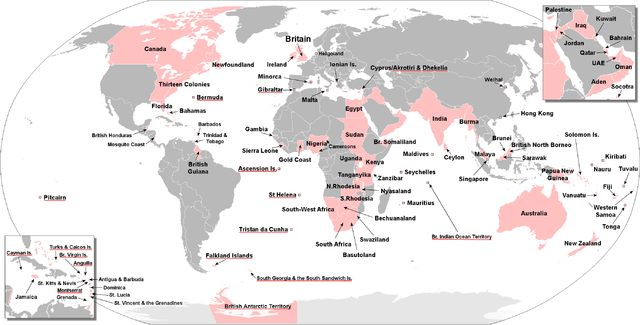
Deutsch: Gebiete, die zur einen oder anderen Zeit Teil des britischen Weltreiches waren. Britische Überseegebiete sind rot unterstrichen.
English: The territories that were at one time or another part of the British Empire. The British Overseas Territories are underlined in red.
Русский: Территории, когда-либо бывшие частью Британской империи. Названия Британских заморских территорий подчеркнуты красным.
|
| Date | 21 December 2008 |
| Source | File:BlankMap-World-large.png and own work by uploader. Composed from maps found in:
|
| Author | The Red Hat of Pat Ferrick |
Licensing
 |
I, the copyright holder of this work, release this work into the public domain. This applies worldwide. In some countries this may not be legally possible; if so: I grant anyone the right to use this work for any purpose, without any conditions, unless such conditions are required by law.
|
File usage
The following pages on Schools Wikipedia link to this image (list may be incomplete):
Metadata
A background to Schools Wikipedia
Through Schools Wikipedia, SOS Children has brought learning to children around the world. SOS Children's Villages is there for the children in our care until they are ready for independence. Help another child by taking out a sponsorship.