
File:Tokyo Landsat.jpg
Size of this preview: 614 × 480 pixels.
| |
This is a file from the Wikimedia Commons. Information from its description page there is shown below.
Commons is a freely licensed media file repository. You can help. |
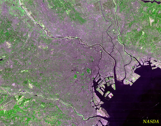
Tokyo Landsat Image. A guided tour:
- The green circle in the centre is the Kokyo (Imperial Palace). The little gray ball in the middle is the palace itself: you can also barely see the Budokan at the top of the palace grounds.
- At the bottom of the photo, on the bay, Tokyo International Airport. The third runway was under construction at the time (or maybe it's just discolored).
- The large artificial islands in the bay near central Tokyo is Odaiba.
- The green blotches west of the Kokyo are the Akasaka Palace and Jingu Park: the big blob far to the west is Yoyogi Park.
- The black spot to the north of Yoyogi Park is central Shinjuku.
- The river on the south side of the photo is the Tama River, separating Tokyo from Kanagawa Prefecture.
- The second river due east of the Palace is the Arakawa, separating Tokyo from Chiba Prefecture.
- The northwestern corner of the map is in Saitama Prefecture, I think (but it's hard to tell exactly where Saitama begins).
 |
This file is in the public domain because it was solely created by NASA. NASA copyright policy states that "NASA material is not protected by copyright unless noted". (See Template:PD-USGov, NASA copyright policy page or JPL Image Use Policy.) |
 |
 |
Warnings:
|
derivative works
Derivative works of this file:
File usage
The following pages on Schools Wikipedia link to this image (list may be incomplete):
More information
Wikipedia for Schools is designed to make learning fun and easy. More than 2 million people benefit from the global charity work of SOS Childrens Villages, and our work in 133 countries around the world is vital to ensuring a better future for vulnerable children. Will you help another child today?