
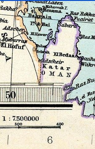
File:Qatar in Stielers Handatlas 1891 59.JPG
Size of this preview: 307 × 479 pixels.
| |
This is a file from the Wikimedia Commons. Information from its description page there is shown below.
Commons is a freely licensed media file repository. You can help. |
Summary
| Description |
English: Qatar in "Iran and Turan Map by Adolf Stieler map 1891"
فارسی: کشور قطر در نقشه ایران و توران در دوره قاجاریه
|
|||||||||||||||||||||||
| Date | 1891 | |||||||||||||||||||||||
| Source |
|
|||||||||||||||||||||||
| Author |
|
|||||||||||||||||||||||
| This is a retouched picture, which means that it has been digitally altered from its original version. The original can be viewed here: Stielers_Handatlas_1891_59.jpg. Modifications made by Geagea.
|
Licensing
|
File usage
The following pages on Schools Wikipedia link to this image (list may be incomplete):
Schools Wikipedia and SOS Children
Schools Wikipedia has made the best of Wikipedia available to students. SOS Children's Villages is there for the children in our care until they are ready for independence. Sponsoring a child is the coolest way to help.