
File:Hebridesmap.png
Size of this preview: 309 × 479 pixels.
| |
This is a file from the Wikimedia Commons. Information from its description page there is shown below.
Commons is a freely licensed media file repository. You can help. |
Summary
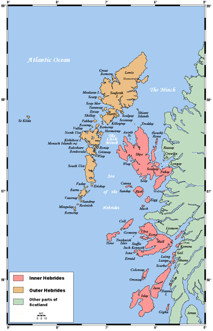
A map of the Inner and Outer Hebrides in Scotland.
This map's source is here, with the uploader's modifications, and the GMT homepage says that the tools are released under the GNU General Public License.
Licensing
|

File usage
The following pages on Schools Wikipedia link to this image (list may be incomplete):
More information
SOS Childrens Villages chose the best bits of Wikipedia to help you learn. SOS Children works in 133 countries and territories across the globe, helps more than 62,000 children, and reaches over 2 million people in total. We have helped children in Africa for many years - you can help too...