  | 
          
            This is a file from the  Wikimedia Commons. Information from its  description page there is shown below.  Commons is a freely licensed media file repository.  You can help. 
           | 


        Summary 


           | DescriptionIsleOfMan SheadingsAndParishes-en.svg | 
           
            
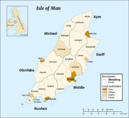
             English: Map of the  Isle of Man, with bounds of sheadings, towns, villages, districts and parishes. 
             Français: Carte es divisions administratives de l' île de Man : sheadings, villes, villages et paroisses. 
             Svenska: Karta över  Isle of Man med gränser mellan sheading, städer, orter, distrikt och församlingar. 
             Македонски: Карта на  островот Ман, со граници на шидинзите, градовите, селата, окрузите и општините. 
             
            | 
          
          
           | Date | 
           28 May 2007 | 
          
          
           | Source | 
           
            
             English: Own work. Based on maps :  
              
             Français: Own work. Basé sur les cartes :  
              
             
            | 
          
          
           | Author | 
            Sémhur | 


          | 
            Camera location 
           | 
          
             54° 12′ 36.00″ N, 4° 32′ 24.00″ W 
           | 
          View this and other nearby images on:  Google Maps -  Google Earth -  OpenStreetMap | 
          ( Info)54.21;-4.54 | 


          This map was improved or created by the  Wikigraphists of the  Graphic Lab (fr). You can  propose images to clean up, improve, create or translate as well.
          
           বাংলা |  català |  česky |  Deutsch |  Deutsch (Sie-Form) |  Ελληνικά |  English |  Esperanto |  español |  suomi |  français |  עברית |  magyar |  Հայերեն |  italiano |  한국어 |  македонски |  Bahasa Melayu |  Plattdüütsch |  Nederlands |  occitan |  polski |  português |  română |  русский |  slovenščina |  svenska |  татарча/tatarça |  Türkçe |  українська |  中文 |  中文(简体) |  中文(繁體) |  Zazaki |  +/−


              | 
           This SVG file uses embedded text that can be easily translated into your language using  this automated tool.  Learn more. You can also download it and translate it manually using a text editor. 


            | 


         Licensing 


           I, the copyright holder of this work, hereby publish it under the following licenses:
           
            
               | 
             Copyleft: This work of art is free; you can redistribute it and/or modify it according to terms of the  Free Art License. You will find a specimen of this license on the  Copyleft Attitude site as well as on other sites. http://artlibre.org/licence/lal/enFALFree Art Licensefalsetrue | 


           You may select the license of your choice.
           | 


       File usage
       
        The following pages on Schools Wikipedia link to this image (list may be incomplete):


       This file contains additional information, probably added from the digital camera or scanner used to create or digitize it. If the file has been modified from its original state, some details may not fully reflect the modified file.
        
       
      Through Schools Wikipedia, SOS Childrens Villages has brought learning to children around the world. SOS Childrens Villages is there for the children in our care until they are ready for independence. Why not try to learn more about child sponsorship?