
File:South Africa racial map, 1979.gif
Size of this preview: 613 × 479 pixels.
| |
This is a file from the Wikimedia Commons. Information from its description page there is shown below.
Commons is a freely licensed media file repository. You can help. |
 |
This map image could be recreated using vector graphics as an SVG file. This has several advantages; see Commons:Media for cleanup for more information. If an SVG form of this image is already available, please upload it. After uploading an SVG, replace this template with {{ vector version available|new image name.svg}}. |
| Description |
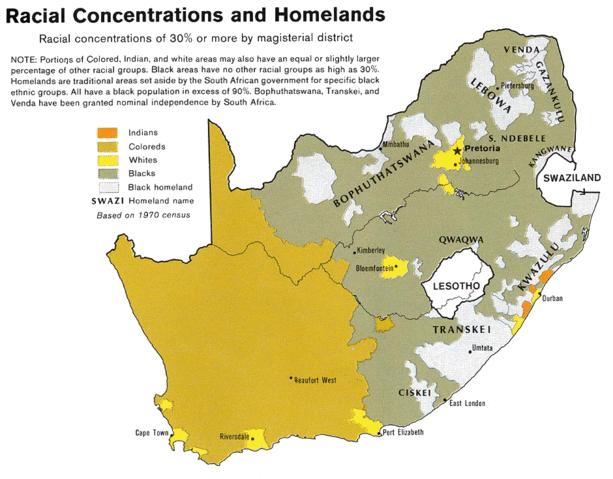
English: Map showing the territorial four main races/ethnicities/colors of South Africa in 1979: Whites, Coloureds, Blacks and Indians. The gray areas indicate the Apartheid-era Bantustans, which are almost exclusively black. This map is a photoshopped version of the CIA-made original map at Perry Castañeda map collection at the University of Texas website.
|
| Date | 1979 (23 August 2008 (original upload date)) |
| Source | Transferred from en.wikipedia; transferred to Commons by User:Magnus Manske using CommonsHelper. (Original text : * Site: Perry-Castañeda Library Map Collection: South Africa Maps
|
| Author | U.S. Central Intelligence Agency. Original uploader was MaGioZal at en.wikipedia |
| Permission ( Reusing this file) |
PD-USGOV-CIA. |
Licensing
| |
This image is a copy or a derivative work of http://www.lib.utexas.edu/maps/africa/south_africa_racial_1979.jpg, from the map collection of the Perry-Castañeda Library (PCL) of the University of Texas at Austin. This tag does not indicate the copyright status of the attached work. A normal copyright tag is still required. See Commons:Licensing for more information. |
 |
This image is a work of a Central Intelligence Agency employee, taken or made as part of that person's official duties. As a Work of the United States Government, this image or media is in the public domain.
|
 |
|
This map image could be recreated using vector graphics as an SVG file. This has several advantages; see Commons:Media for cleanup for more information. If an SVG form of this image is already available, please upload it. After uploading an SVG, replace this template with {{ vector version available|new image name.svg}}. |
{{tlx|...}}
File usage
The following pages on Schools Wikipedia link to this image (list may be incomplete):
Schools Wikipedia and SOS Children
SOS Children chose the best bits of Wikipedia to help you learn. SOS Childrens Villages helps more than 2 million people across 133 countries around the world. Have you heard about child sponsorship? Visit our web site to find out.