
File:Deathvalleysky nps big.jpg
Size of this preview: 639 × 206 pixels.
| |
This is a file from the Wikimedia Commons. Information from its description page there is shown below.
Commons is a freely licensed media file repository. You can help. |
| |
This is a featured picture, which means that members of the community have identified it as one of the finest images on the English Wikipedia, adding significantly to its accompanying article. If you have a different image of similar quality, be sure to upload it using the proper free license tag, add it to a relevant article, and nominate it. |
| |
This image was selected as picture of the day on the English Wikipedia for September 15, 2007. |
|
| Description |
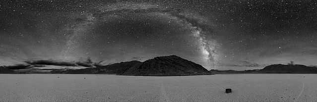
English: 360° panorama of Racetrack Playa in Death Valley at night. The Milky Way is visible as the arc in the centre. A sailing stone is also seen below along with the tracks of other stones.
Deutsch: 360° Panorama-Foto der Racetrack Playa in Death Valley bei Nacht. Die Milchstraße ist als Bogen in der Mitte zu sehen. Zu sehen ist auch ein Wandernder Stein mit seiner Spur sowie die Spuren anderer wandernder Steine.
Español: Fotografía panorámica (360º) nocturna de Racetrack Playa en el Valle de la Muerte. En el centro de la imagen la Vía Láctea es visible con la apariencia de un arco luminoso.
Français : Photo nocturne panoramique (360°) de Racetrack Playa dans la vallée de la mort. L'arc de cercle étoilé correspond à notre voie lactée. Une pierre glissante se trouve au-dessous parmi les pistes d'autres pierres.
|
| Date | 2005 |
| Source | http://antwrp.gsfc.nasa.gov/apod/ap070508.html |
| Author | Dan Duriscoe, for the en:U.S. National Park Service. |
| 360° | View in 360° panoramic viewer |
|---|
|
Camera location |
|
This and other images at their locations on: Google Maps - Google Earth - OpenStreetMap | ( Info) |
|---|
Licensing
 |
This image or media file contains material based on a work of a National Park Service employee, created as part of that person's official duties. As a work of the U.S. federal government, such work is in the public domain. See the NPS website and NPS copyright policy for more information.
|
 |
File usage
The following pages on Schools Wikipedia link to this image (list may be incomplete):
Metadata
Find out more
SOS Children's Villages aims to make Wikipedia suitable for young learners. SOS Children is a global charity founded in 1949 to give children who have lost everything the childhood they deserve. There are many ways to help with SOS Childrens Villages.
Categories: