
File:Continents vide couleurs.png
Size of this preview: 640 × 325 pixels.
| |
This is a file from the Wikimedia Commons. Information from its description page there is shown below.
Commons is a freely licensed media file repository. You can help. |
 |
File:Continents_vide_couleurs-automatedvector.svg is a vector version of this file. It should be used in place of this raster image when superior. File:Continents vide couleurs.png
For more information about vector graphics, read about Commons transition to SVG.
|
 |
Summary
| Description |
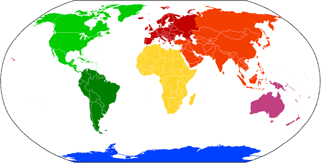
Deutsch: Karte der Kontinente, basierend auf File:BlankMap-World.png. Die Karte enthält keine Beschriftung, damit sie als Grundlage für verschiedene Sprachen benutzt werden kann. Kontinente, für die verschiedene Aufteilungen in Gebrauch sind (z.B. Amerika bzw. Nord-/Südamerika oder Eurasien bzw. Europa/Asien) sind in verschiedenen Abstufungen der selben Farbe gehalten.
Amerika: Nordamerika
Südamerika
Eurasien: Asien
Europa
Afrika
Australien/ Ozeanien
Antarktik
English: Compiled chiefly from File:BlankMap-World.png. Blank to permit labels in various languages. Controversial continents/subcontinents (i.e. one America or two, Eurasia vs Europe and Asia) are in different shades of the same colour:
America: North America not South America
Eurasia: Asia
Europe
Africa
Australia/ Oceania
Antarctica
Français: Carte des continents, depuis File:BlankMap-World.png. C'est vide pour permettre aux gens d'ajouter des étiquettes propres à diverses langues. Les continents/sous-continents dont le statut est controversé (par example une Amérique ou deux, Eurasie vs Europe et Asie) sont illustrés en teints différents de la même couleur.
Italiano: Carta dei continenti, basata su File:BlankMap-World.png. La carta non contiene descrizioni, in modo che possa essere utilizzata in ogni lingua. I continenti che sono spesso menzionati come diversi (ad esempio America e Nord/Sud Amerika) sono mostrati in diverse gradazioni dello stesso colore.
|
||||||||||||||
| Date | |||||||||||||||
| Source | File:BlankMap-World.png | ||||||||||||||
| Author | User:Cogito ergo sumo | ||||||||||||||
| Permission ( Reusing this file) |
|

File usage
The following pages on Schools Wikipedia link to this image (list may be incomplete):
Metadata
A background to Schools Wikipedia
SOS Children chose the best bits of Wikipedia to help you learn. The world's largest orphan charity, SOS Children's Villages brings a better life to more than 2 million people in 133 countries around the globe. Would you like to sponsor a child?