
File:Stonehenge plan.jpg
| |
This is a file from the Wikimedia Commons. Information from its description page there is shown below.
Commons is a freely licensed media file repository. You can help. |
Drawn by en:User:Adamsan from sources:
- Cleal, Walker, & Montague, Stonehenge in its Landscape (London, English Heritage 1995)
- Pitts, M, Hengeworld (London, Arrow 2001)
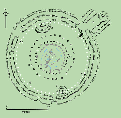
Key to plan:
- 1 = The Altar Stone, a six ton monolith of green micaceous sandstone from Wales
- 2 = barrow without a burial
- 3 = "barrows" (without burials)
- 4 = the fallen Slaughter Stone, 4.9 metres long
- 5 = the Heel Stone
- 6 = two of originally four Station Stones
- 7 = ditch
- 8 = inner bank
- 9 = outer bank
- 10 = The Avenue, a parallel pair of ditches and banks leading 3 km to the River Avon
- 11 = ring of 30 pits called the Y Holes
- 12 = ring of 29 pits called the Z Holes
- 13 = circle of 56 pits, known as the Aubrey holes
- 14 = smaller southern entrance
The site as of AD 2004. The plan omits the trilithon lintels for clarity. Holes that no longer, or never, contained stones are shown as open circles and stones visible today are shown coloured, grey for sarsen and blue for the imported stone, mainly bluestone.
 |
Permission is granted to copy, distribute and/or modify this document under the terms of the GNU Free Documentation License, Version 1.2 or any later version published by the Free Software Foundation; with no Invariant Sections, no Front-Cover Texts, and no Back-Cover Texts. A copy of the license is included in the section entitled GNU Free Documentation License.
|
| This file is licensed under the Creative Commons Attribution-Share Alike 3.0 Unported license. | ||
|
||
| This licensing tag was added to this file as part of the GFDL licensing update.
|
File usage
The following pages on Schools Wikipedia link to this image (list may be incomplete):
Metadata
Wikipedia for Schools...
Wikipedia for Schools is one of SOS Children's Villages' many educational projects. SOS Children's Villages is famous for the love and shelter it brings to lone children, but we also support families in the areas around our Children's Villages, helping those who need us the most. There are many ways to help with SOS Childrens Villages.