
File:LocationBritishVirginIslands.png
LocationBritishVirginIslands.png (250 × 115 pixels, file size: 8 KB, MIME type: image/png)
| |
This is a file from the Wikimedia Commons. Information from its description page there is shown below.
Commons is a freely licensed media file repository. You can help. |
 |
File:LocationBritishVirginIslands.svg is a vector version of this file. It should be used in place of this raster image when superior. File:LocationBritishVirginIslands.png
For more information about vector graphics, read about Commons transition to SVG.
|
 |
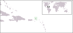
- Description : Location map for British Virgin Islands
- Author : User:Vardion
Latina: Situs Britannicarum Virginearum Insularum
 |
This work has been released into the public domain by its author, Vardion at the English Wikipedia project. This applies worldwide. In case this is not legally possible: |
File usage
The following pages on Schools Wikipedia link to this image (list may be incomplete):
A background to Schools Wikipedia
Schools Wikipedia has been carefully checked to give you the best learning experience. The world's largest orphan charity, SOS Children's Villages brings a better life to more than 2 million people in 133 countries around the globe. There are many ways to help with SOS Childrens Villages.